Experience The Brand New

Web Application
The successor to Meteonorm 8. Rebuilt, from the ground up.
The next generation.
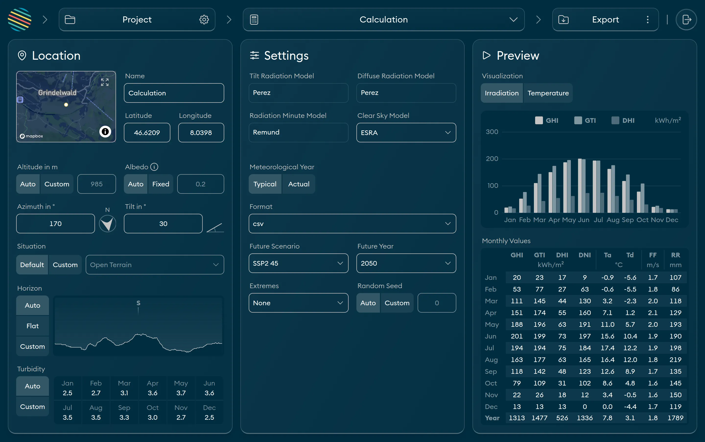
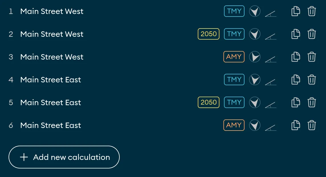
The new Meteonorm application features a project-based workflow that allows you to easily group related calculations. Need different output files? Want to check multiple surface alignments? Or maybe you want to see how your data looks in the future? Just duplicate the calculation and change anything you need. Export everything together. Simple, fast, productive.
All inclusive.
Meteonorm comes with all the bells and whistles you need. Automatic location metadata, typical (TMY) and actual (AMY) meteorological years, complex scenarios, station data around the world and exports in solar industry proven formats.
Made for you.
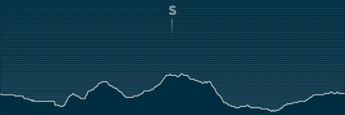
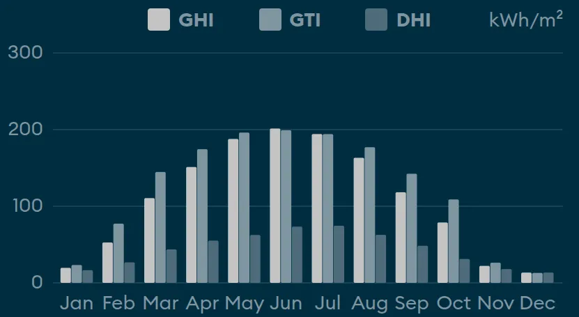
Configuring settings can be tedious. The new Meteonorm App was designed with you in mind. Start with automatic parameters and sane defaults and go deeper where and when you need it. With the built-in graphs, you can visually verify your data without going back and forth between applications. Spend less time getting your data, so you can spend more time building the future.
At a glance.
TMY
Globally available typical meteorological years.
AMYs
Actual meteorological years. Based on observational data.
A Strong Foundation
Expert curated data from 10,000 meteorological stations, 5 satellites, and climate reanalysis.
Extremes
Simulation of irradiance and temperature extreme scenarios. For robust risk assessment.
Climate Change
Future climate scenarios. Including the low, medium and high emission pathways SSP1-2.6, SSP2-4.5 and SSP3-7.0.
Bankability
Meteonorm is an industry-wide standard, trusted by experts.
Powered by Climate API
The web application relies on the Climate API, ensuring it uses precisely the same algorithms, data, and parameters.
File Formats
Export to industry-specific file formats (CSV, JSON, EPW, PVSyst, TMY3, Wufi/WAC).
Parameters
The Meteonorm Web Application delivers 50 parameters for a broad range of applications.
Available Variants
clear sky
horizon shading
Main Parameters
GHI
Global horizontal irradiance
DIR
Direct horizontal irradiance
DHI
Diffuse horizontal irradiance
DNI
Direct normal irradiance
GTI
Global tilted irradiance
BTI
Direct tilted irradiance
DTI
Diffuse tilted irradiance
PV
PV production
RR
Precipitation
Ta
Air temperature
Td
Dew point temperature
snow
Snow depth
Additional Parameters
Extraterrestrial irradiance
Extraterrestrial normal irradiance
Downwelling longwave irradiance
Upwelling longwave irradiance
Vertical longwave irradiance
Photosynthetically active irradiance
Radiation balance
Global illuminance
Direct illuminance
Diffuse illuminance
Linke turbidity
Aerosol optical depth
Cloud cover
Albedo
Surface temperature
Sky temperature
Wet bulb temperature
Mass mixing ratio
Relative humidity
Precipitable water
Driving rain
Atmospheric pressure
Wind speed
Wind direction
Solar elevation
Solar azimuth
Available Variants
clear sky
horizon shading
Don't compromise,
plan for every scenario.
Let's do business together.
Choose your plan.
Basic
per Subscription
192.–
Pro
per Subscription
588.–
* For a request period of 1 year.
** The top-up is only possible in combination with an existing plan.
Custom Offer
Have requirements that go beyond the standard?
Whether you're an educational institution, an ambitious startup, or a big company — we're ready.
Let's build the solution that fits you.
TMY/AMY one-off datasets
If you need a TMY or AMY dataset for a specific location, but do not wish to purchase a paid plan, you can contact us for one-off datasets.